|
|
This year (2014) I've been using a Nook Simple Touch (NST) e-book reader as a repeater for the boat's sailing instruments. The setup has proved very useful but, so far,
is not quite as reliable as I would like.
Elusive has the normal sailing instruments; log, echo sounder and wind speed & direction plus a multitude of GPS devices including chart plotters and AIS
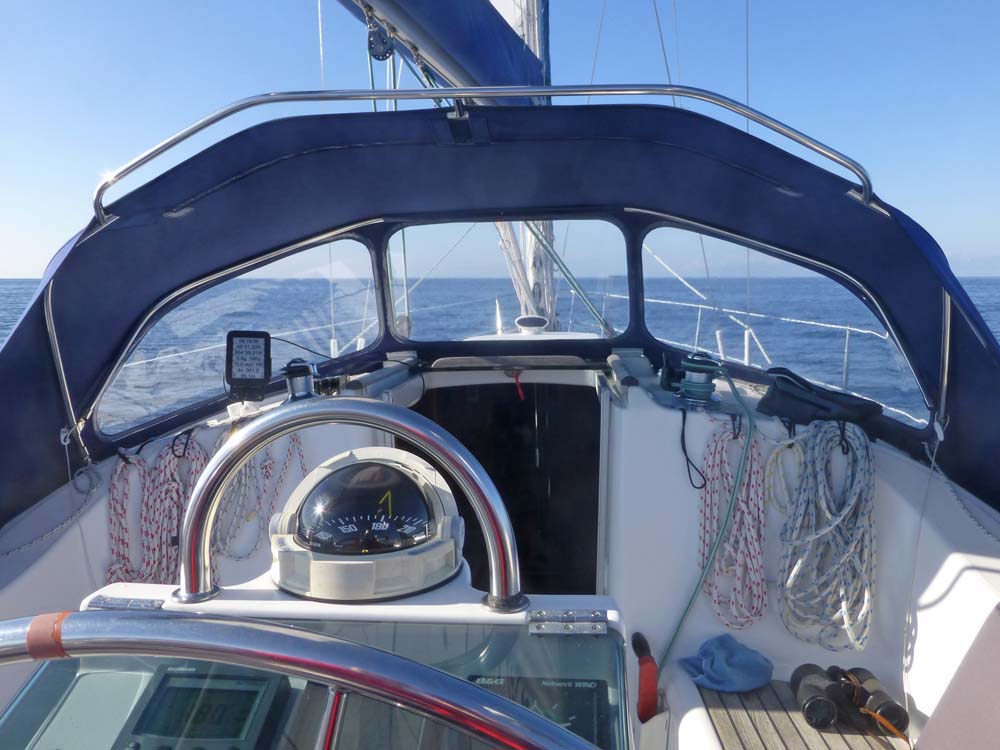
as well as radar and auto-pilot. The sailing instruments and a small plotter are mounted on the binnacle immediately in front of the steering wheel. This is fine for
the helmsman when sitting squarely behind the wheel in "motor-boat mode" but when sailing I like to sit out to one side to see past the genoa and then the instruments
are difficult to read.
The system on our previous boat Jezail was better; the instruments were mounted above the companionway where they could be seen by anyone from anywhere in the cockpit.
So I wanted a repeater situated under the sprayhood which would also allow the information to be displayed in ways that the existing instruments are not capable of.
|
|
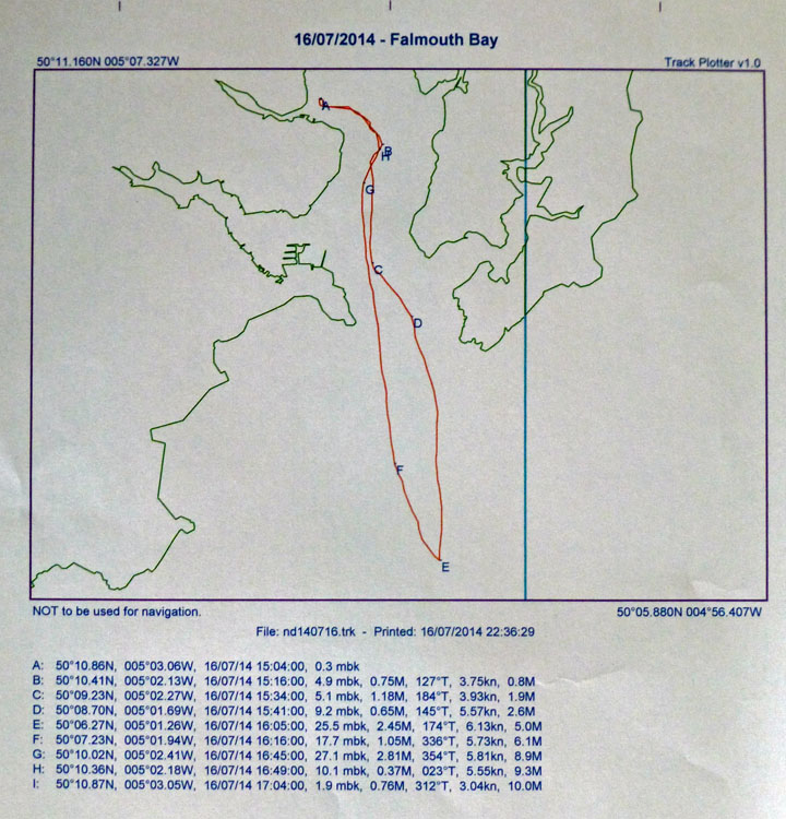 Background: For a long time (over several boats), whenever I've gone sailing, I've recorded the yacht's track so that I can print out a hardcopy in the form
of a plot on a simple outline chart of the neighbouring coast. This paper copy is kept in the ship's log-book and, to me, it is much more evocative of each sail than
the written log. Background: For a long time (over several boats), whenever I've gone sailing, I've recorded the yacht's track so that I can print out a hardcopy in the form
of a plot on a simple outline chart of the neighbouring coast. This paper copy is kept in the ship's log-book and, to me, it is much more evocative of each sail than
the written log.
For much of the time I used a Garmin II+ GPS. This handheld device was ideal for carrying home after each sail for downloading the track to my PC. However, Elusive
has B&G "Network" sailing instruments which communicate with each other over a proprietary link and also output their data in NMEA 0813 format on a serial link so I decided
to capture this information as well.
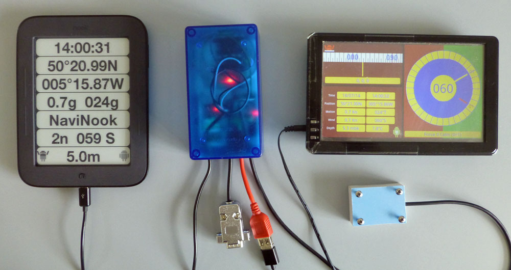
To do this I've been using a Wits A81 Android tablet. The A81 has an internal GPS but it does not have a serial port so I attached an HC06 serial-bluetooth module to the
output of the instruments via a MAX232 level adaptor and the A81 can connect to this using bluetooth. The tablet is programmed in Basic4Android. This has worked well
and there are various options for displaying the data. Unfortunately the colour screen of the tablet is difficult to read out of doors (a problem common to most tablet
displays including my Google Nexus 7) so the A81 stays next to the chart table. The e-ink display of the NST is perfectly legible in sunlight.
|
|
|
I got the idea of using a Nook Simple Touch from the Top Hat Soaring website which details using NSTs as chartplotters for gliding. So I have rooted my NST, upgraded
the operating system and set it up as they suggest.
The NST does not have GPS or a serial port or even bluetooth - just an OTG (on-the-go) USB port. To get data into the NST I'm using an IOIO interface.
The A81 now transmits the instrument data plus the GPS data back through the bluetooth link and the HC06 passes it to the input of the IOIO.
The NST is also programmed in Basic4Android.
|
|
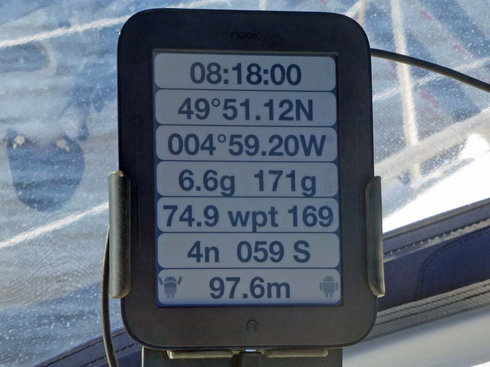
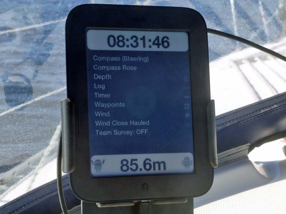
The basic display - seven lines of text.
1) Time (UTC)
2) Latitude
3) Longitude
4) Speed and Course - the "g"s indicate "over the ground" (from the GPS). There is the option for water speed from the log and magnetic heading from an electronic compass.
5) Distance & Bearing of the active waypoint.
6) Wind Speed & Relative Direction - 4 knots, 59 degrees on the starboard side.
7) Depth (m) below keel. The Android icons are control buttons. The lefthand one is for "Man Overboard" - it sets the current position as the active waypoint. The righthand one calls the menu.
|
|
The menu showing the main display options - there are other options relating to data sources etc reached by scrolling the list.
Note that time and depth are always visible.
|
|
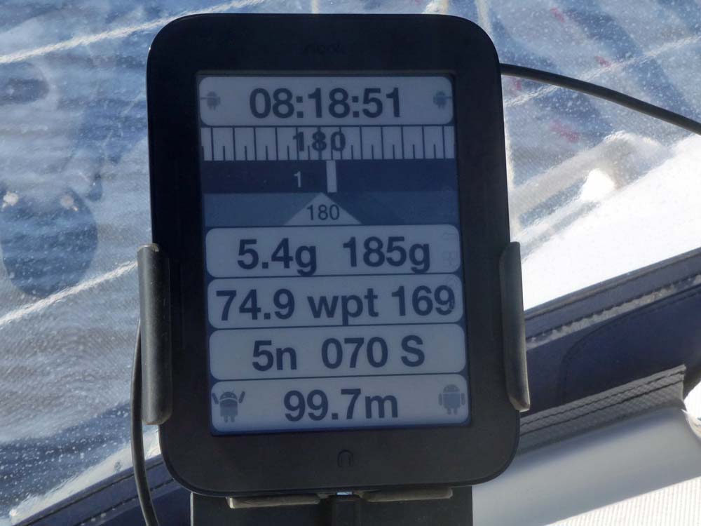
The "Steering Compass" option.
The Lat & Long rows have been replaced by a graphic of a compass which moves with the ship's heading. The thick white bar in the centre is the index, the No.1 nearby shows the bearing of the active waypoint.
Tapping this display brings up the arrowhead at the bottom which is locked to the instantaneous heading at that time. This can be fine-tuned using the little Andoid icons that are shown either side of the time.
|
|
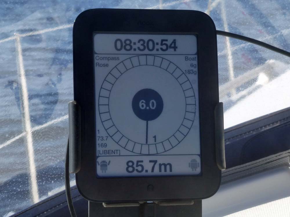
The "Compass Rose" display.
This replaces all the text rows except time and depth.
The pointer indicates the ship's heading and the No.1 is at the bearing of the waypoint. The number in the centre is boat speed.
Details of the boat's speed and heading are at the top right. Details of the waypoint (the Libenter Buoy off L'Aber Wrac'H) are at the bottom left.
A second waypoint can also be selected. The details would be shown bottom right.
I've since added a second pointer for the desired heading like the arrowhead in the previous photo.
|
|
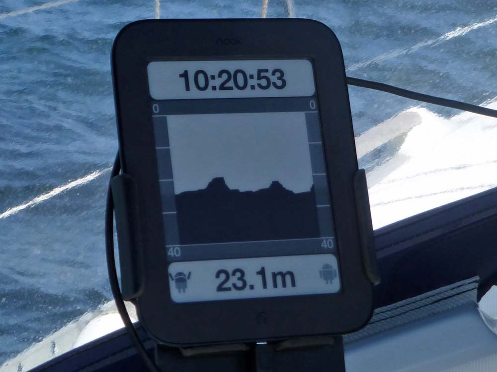
Depth.
This shows about 5 minutes history of depth readings - very useful when scouting out an anchorage.
|
|
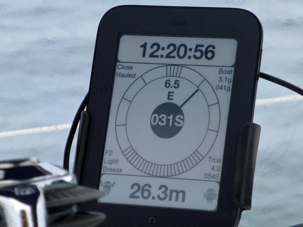
Close-Hauled Wind Indicator.
Each interval of the scale is ten degrees. The scale between twenty and sixty degrees is expanded to magnify changes in apparent wind direction in this critical sector.
The relative apparent wind direction is shown in the centre with absolute true wind direction above it as a cardinal and then apparent wind speed at the top.
The relative true wind direction and speed is bottom right with the Beaufort details at bottom left.
The Wind display is similar but with a uniform scale. A second pointer shows the relative true wind direction.
|
Update: Spring 2015.
The Nook works really well as a cockpit display being clearly ledgible from any steering postion.
The initial reliability problems proved to be dust blocking the touchscreen sensor (its an infra-red scanning system).
Once I realised this the problem was easily avoided.
The setup shown is not very logical - it was just an evolution of other things I had been trying.
I'm now working on the Mk.II version which is a complete reconfiguration but the display on the Nook will remain the same.
The new setup will use more serial ports of the IOIO to allow data to be shared among more pieces of equipment.
|
Mk.II: Autumn 2015.
|
Schematic diagram.
The objective of the changes was to re-establish my main chart plotter, a Standard Horizon CP300i at the centre of of the navigation sytem and to
distribute all the available data to each component that can make use of it.
|
The IOIO now has three serial ports. The first (Port 0) has both input and output connected to the main chart plotter.
The second port (Port 1) takes its input from the sailing instruments but outputs to a HC06 bluetooth module.
The input of the third port (Port 2) takes the DSC output my VHF transceiver and the output goes to the autopilot and to a Standard Horizon CP155
chart plotter that is mounted on the steering pedestal.
The IOIO sends all the data it receives to the Nook via the OTG connection and the Nook sends it back to the IOIO after multiplexing sentences from the
various sources into the approprite output streams.
The chart plotter transmits GPS data to the IOIO and receives sailing instrument data back. This GPS data includes details of the active waypoint
as well as position and movement. The instruments (Log, Depth & Wind) transmit to the IOIO Port 1 as before but the IOIO now sends all the data
(GPS and LDW)to the output of Port 2 and this is broadcast over the bluetooth link to a redundant mobile phone which has replaced the now defunct android
tablet as a data logger/display. The GPS in the phone is only used as a backup; the position data normally displayed and recorded comes from the plotter.
This arrangement has worked well during 2015. It streamlines operations as active waypoints are only selected on the plotter whereas before they had
to be selected on the Android tablet as well. This prevents discrepancies occuring.
Also, having the plotter data displayed on the phone means that it no longer has to be displayed on the plotter.
This allows the whole of the plotter screen to be used for the chart whereas, previously, about a third of the screen was used for text data.
This may seem to add a significant amount of complexity to achieve very little, but I think the way the components have been conected ensures that if
any part of the home-brewed setup should fail, the essential navigational requirements will not be adversely affected.
|
|
Multiplexer
|
Another component that has just been added is an Arduino Mega that acts as a multiplexer joining the output of the AIS and that of the LDW into
a single stream which is then imput into the single NMEA 0183 port of the B&G Zeus T7 multifunction display. The T7 is mainly used as a display
for the RADAR but it includes software that can provide a sophisticated display of sailing performance when supplied with the LDW data.
The AIS data is received at an unusually high baud rate of 38400 whereas the LDW stream is at the conventional 4800 baud. The combined output is transmitted
at the higher baud rate.
In addition, the wind information which is received as an NMEA MWV sentence is translated into a VWR sentence as the former is now deprecated
and not understood by the T7.
|
Mk.III: Spring 2016.
|


